| auction house |
Hereditas Antikvárium |
| date of auction |
d-m-Y H:i |
| title of auction |
Fair Partner ✔
16. Könyvárverés |
| date of exhibition |
2025. május 26 - június 5. | hétköznap 11.00 - 17.00 óráig |
| auction contact |
+36 30 442 1386 | info@hereditasantikvarium.hu | www.hereditasantikvarium.hu |
| link of auction |
https://axioart.com/aukcio/2025-06-06/16-konyvarveres-hereditas |
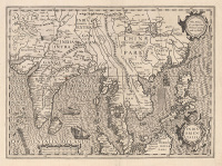
183. item
Jansson, Jan: Indiae Orientalis Nova Descriptio
Amsterdam, 1630.
A rare copperplate map of Southeast Asia, the Philippines, and Western Australia by Jan Jansson. It is a landmark in the history of cartography and is an important contribution to the mapping of the Philippines and was one of the first to publish Willem Janszoon’s landing on the coast of Australia. The navigator sailed along the southern coast of New Guinea on behalf of the Dutch East India Company in his ship Duyfken. He crossed Torres Strait (before Luís Vaz de Torres), landed west of Cape York, and began to map the area (the part marked „Duyfkens Eylant” on the engraving) that he believed was part of New Guinea. The map field shows the region from north to south, from southern China beyond Java and Timor to the Timor Sea, and from west to east, from the Andaman and Nicobar Islands to the Mariana Islands. The depiction features illustrations commonly used in the golden age of cartography, ships, sea monsters, finely crafted compass roses, and elegant cartouches adorn the page. Our copy is a rare, early print with empty verso.
Dimensions: 390 x 505 (410 x 540) mm.Fine, clear copy.
van der Krogt I.: 8500:1B.1., Koeman II.: Me 243.