| Auktionhaus |
Hereditas Antikvárium |
| Datum der Auktion
|
d-m-Y H:i |
| Titel der Auktion |
Fair Partner ✔
16. Könyvárverés |
| Datum der Ausstattung |
2025. május 26 - június 5. | hétköznap 11.00 - 17.00 óráig |
| Erreichbarkeit der Auktion |
+36 30 442 1386 | info@hereditasantikvarium.hu | www.hereditasantikvarium.hu |
| Link der Auktion |
https://axioart.com/aukcio/2025-06-06/16-konyvarveres-hereditas |
175. Artikel
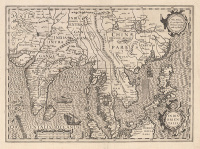
De Jode, Gerard: Secundae partis Asiae…
Antwerpen, 1593.
A rare copperplate map of the Arabian Peninsula by Gerard de Jode, one of the earliest regional representations still available to collectors. Initially produced for the first edition of the atlas “Speculum Orbis Terrae”, it was later included in the second edition by his son, Cornelis (this item is one of these copies). The map field extends west to east from the Nile Valley, encompassing the Arabian Peninsula, the Persian Gulf, and the Arabian Sea in the centre, to the western coast of India. The cartographic basis, as mentioned in the title, was the work of Giacomo Gastaldi. Its nomenclature is as detailed as in our previous item, with an attempt to compensate for cartographic shortcomings by using illustrations, relief elements, and larger fonts. The engravers – Jan and Lucas van Deutecum – illustrated the sheet with a classical-style cartouche and a compass rose, with Latin text on the back.
Dimensions: 330 x 505 (375 x 535) mm. There is a paper strip on the back along the centrefold, and a few light stains in the upper centre of the map field.
van der Krogt III.: 8180:32., Koeman II.: Jod2 9.